Student Research Pages - Texas Storms!
Texas Storms!
Many types of dramatic storms come to Texas each year.
Tornados
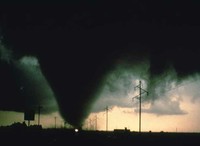
The Texas Panhandle has a reputation for its crazy twisters. Tornados begin when warm air gets pushed upwards, carrying water droplets with it. As the air spins, it makes a vortex.
Tornados can spin up to 300 mph! Whoa...dizzy yet?
Storm Safety Tip:
One of the safest places to wait out a tornado is curled up in your dry, empty bathtub.
No matter where you hide during a tornado, protect the back of your neck. It’s very fragile (that means can break easily) and very important. During tornados the violent wind blows lots of things all around. You don’t want to get bonked anywhere, but especially on the back of your neck!
Hurricanes
These mighty storms brew over oceans. Since Texas rests against the Gulf of Mexico we sometimes get visited by their fury. When hurricanes reach land their winds can blow over 100 mph!
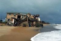
This picture shows how a hurricane can practically blow down a house.
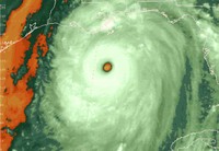
See this photo? It shows what a hurricane looks like from the sky. That dot in the middle is called the "eye" of the hurricane. Strangely, things are very peaceful at the eye of the hurricane.
One of the deadliest hurricanes in Texas history struck Galveston in 1900. Back in those days we didn't have TV's or radios to warn us so no one knew the storm was approaching. Over 6,000 people died! Yikes!
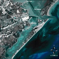
Galveston is located in a vulnerable place. "Vulnerable" means that it can be harmed easily. Look closely at this photograph:
Do you see what we mean when we say that Galveston is located in a vulnerable place? Learn more about the Galveston storm and see lots of photos at: http://www.1900storm.com/.
Today, weather tools like radar warn us when hurricanes head our way. Meteorologists like Paul Yura alert us so we have time to evacuate. "Evacuate" means leave and go somewhere safe.
Go to this link to see if there are any real life hurricanes to track right now: https://www.wunderground.com/hurricane
Storm Safety Tip:
Listen to the advice of meteorologists and evacuate when they tell you to do so!
Thunder & Lightning
Special kinds of clouds called cumulonimbus (coom-you-low-nim-bus) have both frozen rain drops and warm air.
Some folks like to call cumulonimbus clouds like this one "thunderclouds" because that's easier to say!
Thunderclouds have both frozen rain drops and warm air that move around and bump into each other. This creates electricity.
FLASH!
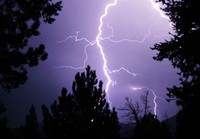
When they create electricity we see it as lightning.
BOOM!
Then...lightning makes thunder.
As electricity travels to different places making light, it creates openings in the air. When an opening closes, it makes a super loud noise. We call that noise "thunder."
Want to hear some thunder? Check out Freesound and search thunder.
We see lightning before we hear thunder because light travels faster than sound.
Storm Safety Tips:
Since lightning is electricity and electricity is attracted to water, stay away from water during a lightning storm!
Remember that Mr. Yura said to stay away from trees as well. And his most important advice was:
When thunder roars, go indoors!
