Legend:
- Download Acrobat Reader to review PDF documents referenced on this page.
- Please visit our accessibility information if you need assistance in accessing, opening, or reading the PDF documents referenced on this page.
Texas Partners in Flight
Ecoregional Bird Checklists
Click on a region of interest to go to a description of the region(s) and a link to download a PDF version of the related birding checklist publication.
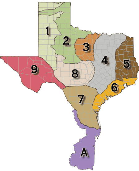
 Region 1: Pecos and Staked Plains (aka High Plains or Llano Estacado)
Birds of the High Plains and Rolling Plains of Texas PDF
Description — The Staked and Pecos Plains cover the western panhandle of Texas, the west end of the panhandle of Oklahoma, and extensive areas in eastern New Mexico. These high and dry plains are covered with a shortgrass prairie dominated by grama and buffalo grasses. There are also extensive areas of shinnery, a midgrass prairie with low shrubs. The area grades into taller grass to the east, to Trans-Pecos shrub savannah to the south, and more chaparral and pinyon-juniper in the Mesas and Plains area to the west. The northern border of Oklahoma is established as an arbitrary northern limit. Text by Pashley, David N., et al. 2000. Partners in Flight Conservation of the Land Birds of the United States. American Bird Conservancy, ThePlains, VA.
 Region 2: Rolling Red Plains (aka Rolling Plains)
Birds of the High Plains and Rolling Plains of Texas PDF
Description — The Rolling Red Plains extend north from the Edwards Plateau in Texas to western sections of Oklahoma. The landscape is flat to rolling plains, with natural vegetation consisting of mixed grass plains, short grass high plains, shinnery oak grasslands, and mesquite grasslands. The mixed grass plains association is the transition zone between the tall grass prairie association and other associations that are located in the western part of the physiographic area. Grasses and forbs are the dominant vegetation. The shinnery oak grasslands are located in broad rolling topographic relief of the western and northern part of the area. Oak mottes occur throughout broad expanses of tall, mixed, or short grasses. The mesquite- grassland type is perhaps the most extensive of communities in the area. This association typically occurs on flat to gently rolling topography, and is characterized by open canopy of short mesquite trees with an understory of prickly pear and thorny scrub. These natural communities were maintained by a variety of harsh weather events, including severe winter weather, cycles of hot temperatures and drought, and tornadoes. Text by Pashley, David N., et al. 2000. Partners in Flight Conservation of the Land Birds of the United States. American Bird Conservancy, The Plains, VA.
 Region 3: Osage Plains (aka Cross Timbers)
Birds of the Oaks and Prairies and Osage Plains of Texas PDF
Description — The Osage Plains, covering west-central Missouri, the southeastern third of Kansas, most of central Oklahoma, and extending into north-central Texas, is the southernmost of three tallgrass prairie physiographic areas. It grades into savannah and woodland to the east and south, and into shorter mixed-grass prairie to the west. The Osage Plains consist of three subregions. The Osage Plains proper occupy the northeast segment. Although sharply demarcated from the Ozark uplift, the Plains are nonetheless a transitional area across which the boundary between prairie and woodland has shifted over time. In the central portion of the physiographic area lies the second subregion, the Flint Hills. This large remnant core of native tallgrass prairie is a rocky rolling terrain that stretches from north to south across Kansas and extends into Oklahoma. To the west and south of these hills are the Blackland Prairies and Crosstimbers. This vegetatively complex region of intermixed prairie and scrubby cedar-mesquite woodland extends into north-central Texas. As in the rest of the Great Plains, fire, herbivory, topography, and drought maintained prairie and established the location of woodlands. Text by Pashley, David N., et al. 2000. Partners in Flight Conservation of the Land Birds of the United States. American Bird Conservancy, The Plains, VA.
 Region 4: Oaks and Prairies (aka Post Oak Savannah and Blackland Prairie)
Birds of the Oaks and Prairies and Osage Plains of Texas PDF
Description — The Oaks and Prairies extend from approximately the Red River of Oklahoma south to San Antonio, Texas, east to the acidic sandy soils of the East Texas Pineywoods and west to the Eastern Cross Timbers. Within this area, the Texas Blackland Prairie represents the southernmost extension of the North American tallgrass prairie. In this subregion, the principal habitat is tallgrass that typically occurs on higher areas with good drainage. Eleven plant associations have been described in the Blackland Prairie, and dominant vegetation includes big bluestem, little bluestem, Indiangrass, switchgrass, brownseed paspalum, and gramagrass. Also present in the Oaks and Prairies physiographic area are bottomland hardwood forests, where burr oak, Shumard oak, black walnut, American elm, cedar elm, and white ash are common components. Riparian forests include cottonwood, sycamore, black willow, and green ash. Common trees of upland hardwood forests occurring on the upper slopes and summits of Austin chalk escarpments include Texas oak, San Saba oak, Mexican plum, and cedar elm. There is often an associated dense scrub layer within these forests, including species such as aromatic sumac, poison oak, Carolina buckthorn, and coralberry. There are occasional wetlands and freshwater marshes in the Oaks and Prairies area, primarily associated with the peripheral areas of streams, rivers, and reservoirs. Text by Pashley, David N., et al. 2000. Partners in Flight Conservation of the Land Birds of the United States. American Bird Conservancy, The Plains, VA.
 Region 5: West Gulf Coastal Plain (aka Pineywoods)
Birds of the Pineywoods of Eastern Texas PDF
Description — The West Gulf Coastal Plain covers northwest Louisiana, southwest Arkansas, easternmost Texas, and the southeast corner of Oklahoma. In general, uplands are dominated by pines and bottomlands by hardwood forests. The pine is originally longleaf in the southern portion and shortleaf with a significant hardwood element in the northern portion. The southern edge of the physiographic area occurs where trees become less dominant and the grasslands of the Coastal Prairies begin. The West Gulf Coastal Plain extends east to the Mississippi Alluvial Valley and north to edge of the Ouachita highlands. Drier climate and changing soils to the west mark the edge of the distribution of pine in eastern Texas and the beginnings of the Oaks and Prairies physiographic area. Text by Pashley, David N., et al. 2000. Partners in Flight Conservation of the Land Birds of the United States. American Bird Conservancy, The Plains, VA.
 Region 6: Coastal Prairies
Check List not completed yet.)
Description — The Coastal Prairies physiographic area covers approximately 880 km of coastal shoreline from Atchafalaya Basin, Louisiana to Baffin Bay, Texas. The inland boundary of this area ranges from 15 km to 150 km from the coast, capturing a complex of marshes and upland grassland and a very small amount of forested habitat. Marsh vegetation is determined largely by the salt content of the water, with community types ranging from salt marsh to brackish to fresh water marsh. Nearly all grassland habitats have been converted to agricultural use, primarily pasture lands and rice farms. Forested areas occur primarily along major riverine systems and on coastal cheniers (ancient beachfront ridges), mottes and salt domes, and man-made levees and spoil banks. The Chenier Plain is an important sub-unit of the physiographic area that is located from Atchafalaya Bay, Louisiana westward to East Bay, Texas. Wooded subunits comprise only about 6% of the Chenier Plain and occur on the cheniers themselves. These are long narrow bands of woodlands dominated by hackberry and live oak that run parallel to the Gulf Coast and range in width from about 30 to 500 m and in length from about 1 to 50 km. Bottomland hardwood forests along the major river systems that drain the Coastal Prairies range in composition from cypress-tupelo to hackberry-ash-elm to water oak-willow oak dominated forests. Text by Pashley, David N., et al. 2000. Partners in Flight Conservation of the Land Birds of the United States. American Bird Conservancy, The Plains, VA.
 Region 7: South Texas Brushlands (aka Tamaulipan ThornScrub)
Birds of the South Texas Brushlands (AKA Tamaulipan Scrub) PDF
Description — The South Texas Brushlands physiographic area, entirely in southern Texas, is part of the Tamaulipan biotic province that extends into Mexico at least as far as the Rio Soto la Marina in Tamaulipas and the Monterrey region of eastern Nuevo Leon. The area is dominated by chaparral, or brushland habitat, and fairly recent agricultural fields. However, the region also includes fairly extensive grasslands, oak forests, and some tall riparian forests. In the brushlands, much of the area was originally covered by mesquite-acacia savanna, and areas of semi-open thorn scrub generally less than 3 meters tall alternating with grassy areas. The relative coverage of grassy areas is questionable, and may have varied during wet-dry cycles. Forested areas included live oak mottes and taller riparian zone forests along the Rio Grande, Nueces and other rivers. Cenizo, or purple sage, covered some of the area as well, mainly on caliche capped ridges along the Rio Grande and Bordas escarpment. Coastal acreage, relatively small in this physiographic area, were once dominated by a complex of coastal marsh, upland grasslands, and floodplain forest. Text by Pashley, David N., et al. 2000. Partners in Flight Conservation of the Land Birds of the United States. American Bird Conservancy, The Plains, VA.
 Region 8: Edwards Plateau (aka Texas Hill Country)
Birds of the Edwards Plateau PDF
Description — The Edwards Plateau is entirely contained within Texas. This hilly area is clearly demarcated by the Balcones Fault escarpment to the east and south, but grades into the Chihuahuan Desert to the west and the Great Plains to the north. The plateau can be divided into four subregions. The central and western portions of the plateau are characterized by broad, relatively level uplands moderately dissected by gently sloping stream divides. The deeply dissected portion adjacent to the escarpment, the Balcones Canyonlands, is popularly known as the Texas Hill Country. This region is highly dissected by fast-moving streams through steep-sided canyons. The northeast plateau, the Lampasas Cut Plains, is characterized by broad valleys. The final subregion is the Central Mineral Valley or Llano Uplift. This area has a granitic substrate that clearly differentiates this area from surrounding areas.
The Edwards Plateau was originally a grassy savannah with the most common trees being mesquite, juniper, and live oaks. Some of this community type still remains, but agricultural practices have heavily modified most of the area. The eastern and wetter end of the Plateau is characterized by diverse woodlands including hardwoods (primarily oaks) and Ashe Juniper. Periodic, naturally-occurring fire was a major ecological force in the western plateau that maintained live oak savannahs and produced a mosaic of habitats across broad landscapes. Text by Pashley, David N., et al. 2000. Partners in Flight Conservation of the Land Birds of the United States. American Bird Conservancy, The Plains, VA.
 Region 9: Chihuahuan Desert (aka Trans-Pecos)
Birds of the Chihuahuan Desert PDF
Description — In the United States, the Chihuahuan Desert includes the Trans-Pecos of Texas, southern New Mexico, and a small area in southeast Arizona. Broad basins and valleys bordered by sloping alluvial fans and terraces make up the dry lowlands of this region, punctuated by occasional mesas and mountain ranges. The Rio Grande and Pecos are the primary rivers of the Chihuahuan Desert. In this arid region, riparian corridors provide important habitat for breeding, in-transit, and wintering birds. Other drainages end in closed basins and include few permanent streams. Arid grass and shrubland are the primary lowland vegetation types, often dominated by creosote. This grades uphill into oak-juniper woodlands and even coniferous forest in the highest reaches. The Madrean mountains mark its western edge, the Edwards Plateau its east, and the reduced shrubbiness of the shortgrass plains its north. The Chihuahuan Desert extends south across much of the Central Plateau of Mexico, bordered by the Sierra Madre Occidental and Oriental. Text by Pashley, David N., et al. 2000. Partners in Flight Conservation of the Land Birds of the United States. American Bird Conservancy, The Plains, VA.
Note of Appreciation:
Texas Parks & Wildlife Department extends its thanks to Partners in Flight — www.blm.gov/wildlife/pifplans.htm for ecoregion definitions and descriptions used above.
 El Cielo Biosphere Reserve in the State of Tamaulipas, Mexico
Birds of the Gomez Farias Region, Southwestern Tamaulipas, Mexico PDF
Description — The Gómez Farías Region lies in the southwestern part of the state of Tamaulipas in northeastern Mexico, some 385 km. (240 mi.) to 425 km. (265 mi.) south of the United States border at Brownsville, Texas. As defined here, the Region includes the area along and west of Mexico Highway 85 to a north-south line drawn along the main axis of the Sierra Madre Oriental, some 32 km. (20 mi.) distant. Its northern limit lies approximately on a latitude with the village of Felipe Angeles on Hwy. 85, and its southern limit on a latitude with the junction of Hwy. 85 and the side road to Gómez Farías. The Region thus contains virtually all the drainage of the Rio Sabinas, a fairly narrow band of the coastal plain, and the eastern face of the Sierra Madre Oriental. Since the first edition of this checklist was written, a “Man in the Biosphere Reserve” has been established to protect the rich diversity of the Region. The El Cielo Biosphere Reserve encompasses 144,530 ha., and is contained totally within the area covered by this checklist. An intermontane valley just west of the crest of the main ridge marks the western edge of the Region. Villages in the Region include Gómez Farías, El Encino and La Joya de Salas. Rancho El Cielito is located on the Rio Sabinas at about l00 m. (330 ft.) and Rancho del Cielo at about l500 m. (4000 ft.) on the eastern face of the Sierra Madre Oriental. These properties are biological stations owned and operated by the Gorgas Science Foundation, Inc. Most current ornithological research and bird observation is carried out by persons using these facilities. Text by John Arvin.
For additional information write to:
Texas Partners in Flight Program
Texas Parks and Wildlife Department
4200 Smith School Road
Austin, TX 78744
nature@tpwd.state.tx.us