Freshwater Inflow Recommendation for the Guadalupe Estuary of Texas
Executive Summary
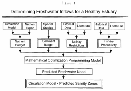
Freshwater inflows (FWI) from rivers, streams, and local runoff maintain the proper salinity gradients, nutrient loadings, and sediment inputs that in combination produce an "ecologically sound and healthy Estuary." This report summarizes studies that form the basis for TPWD's recommendation of target freshwater inflows needed to maintain the unique biological communities and ecosystems characteristic of a healthy Guadalupe Estuary in Texas. Primary methods for determination of coastal freshwater inflows, developed by the State Bays and Estuaries Research Program [consisting of the Texas Water Development Board (TWDB) and Texas Parks & Wildlife Department (TPWD)], rely on computer optimization and hydrodynamic modeling as basic predictive techniques (Figure 1). These models result in theoretical estimates of a minimum FWI (termed the MinQ flow) and maximum harvest FWI (termed MaxH flow) for each Estuary. In the next phase (Figure 2), the MinQ and MaxH target flows predicted from optimization modeling are critically evaluated by TPWD for effectiveness in satisfying biotic needs of the Estuary. TPWD studies focus on evaluating fisheries survey data from the TPWD Coastal Fisheries Resource Monitoring Database. Observed abundances of estuarine fishery species are empirically evaluated against FWI regimes proposed from the theoretical modeling. By comparing predicted results with observed fisheries survey data, a final recommendation is proposed consistent with TPWD's goal of FWI needed for a "biologically healthy and productive" Guadalupe Estuary.
Review of TWDB/TPWD Modeling Results
The Estuarine Mathematical Programming or Optimization Model (TXEMP) produces a range of solutions that simultaneously predict seasonal (monthly) inflows (Figure 3), and the corresponding estuarine fishery harvests (Table 1), which satisfy model input constraints. The monthly flow targets for MinQ and MaxH cases are also listed in Table 2. Output from TXEMP serves as input to the two dimensional, finite element hydrodynamic circulation model (TXBLEND) which simulates patterns of salinity distributions and bay circulation.
Table 1. Predicted Species Harvest (in thousands of pounds) Under Two Inflow Simulations
Species |
MinQ |
MaxH |
Blue Crab |
255.5 | 379.9 |
Oyster |
609.7 | 702.7 |
Red Drum |
63.8 | 84.0 |
Black Drum |
32.4 | 32.4 |
Spotted Seatrout |
113.0 | 114.8 |
Brown Shrimp |
547.8 | 704.0 |
White Shrimp |
918.2 | 910.3 |
Total Harvest |
2540.4 | 2928.0 |
Table 2. Monthly Inflow Needs (in thousands of acre-feet) of Guadalupe Estuary for Two Simulations.
Month |
MinQ |
MaxH |
January |
111.2 | 111.2 |
February |
124.2 | 124.2 |
March |
52.4 | 52.4 |
April |
52.4 | 52.4 |
May |
186.0 | 222.6 |
June |
136.0 | 162.7 |
July |
60.8 | 88.6 |
August |
60.8 | 88.6 |
September |
52.4 | 52.4 |
October |
52.4 | 52.4 |
November |
73.8 | 73.8 |
December |
66.2 | 66.2 |
Total Needs |
1028.8 | 1147.4 |
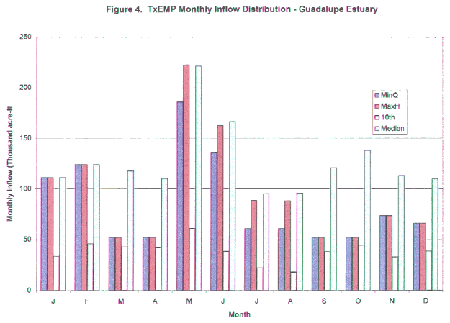
Minimum annual inflow (MinQ) was computed to be 1.03 million acre-ft/year and MaxQ (maximum annual inflow) was 1.29 million acre-ft/yr. Optimal flow producing maximum fisheries harvest (MaxH) within the range of inflows between MinQ and MaxQ was determined to be 1.15 million acre-ft/yr. Figure 4 compares the monthly inflow distributions for MinQ and MaxH cases to the two historical inflow boundary cases, namely the median (50th percentile) and 10th percentile flows. Despite the small difference between MinQ and MaxH flows (ca 9 %), the difference in total fisheries harvest between the two cases (2.54 vs. 2.93 million pounds for MinQ vs. MaxH, respectively) is significantly larger (ca 15 %), as shown in Table 1. The MaxH flow produces higher harvests of blue crab, oysters, and brown shrimp than MinQ.
Verifying Biological Responses to Historical Freshwater Inflows
Two types of biological assessments were performed in order to validate the computed FWI targets: 1) Evaluation of the biotic suitability of seasonal salinity zones predicted from the hydrodynamic model; and 2) Correlating historical abundance of representative fisheries biota with observed seasonal salinity regimes (as a proxy for FWI).
Effects of MinQ vs. MaxH Salinity Regimes Predicted by Modeling
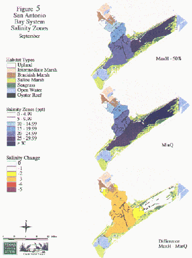
Geographic information system (GIS) techniques were used to compare salinity maps from the hydrodynamic model under optimized MaxH or MinQ inflows. Salinity zone maps were generated by contouring the salinity output from model runs using Arc/Info GIS software. Salinity change analysis was performed by overlaying MinQ and MaxH salinity maps for each month, producing salinity difference maps between MaxH and MinQ (Figure 5 ). Locations of wetlands and oyster reefs were also overlaid onto the monthly plots of predicted salinity zones to aid in interpreting impacts. The distribution of sensitive marsh wetlands in the Guadalupe Bay Delta (2,634 ha of brackish marsh and 2,664 ha of intermediate/fresh marsh) and 4,300 ha of submerged vegetation (seagrass) in other parts of the Bay were considered critical to this evaluation (Figure 5).Examination of the salinity difference maps indicated that salinity zones were essentially identical (< 1.0 ppt difference) between MaxH and MinQ cases from January until May. From May to September, progressively larger salinity differences were evident between the two cases in the Upper and Middle parts of the Bay. The largest actual difference in salinities for the entire year between the two model cases (a high of 3 ppt near the Delta in the Upper Bay) was observed for the month of September (Figure 5 ). These moderately higher MinQ salinities (ca 10 - 14.9 ppt) compared to MaxH conditions near the Delta are noteworthy. Some stress to salt-sensitive wetland vegetation or benthic fauna in the Delta could be caused by these MinQ salinity regimes during summer to early fall.
Time Series Analysis of Salinity at Critical Bay Sites
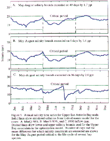
Time-series analyses were also performed on the salinity data from the TXBLEND model at selected sites in the Bay to determine when the salinity constraints would be exceeded (Figure 6 ). The MinQ case had slightly higher average salinities and exceeded salinity constraints in the Upper Bay more often than did the MaxH. During the critical summer months when shrimp, crabs, and young-of-the-year fish species depend on the estuary for habitat and food resources, the MinQ case exceeded the maximum salinity constraint for 49 days by an average of 1.7 ppt in the Upper Bay.
Spatial Analysis of Preferred Salinity Zones for Target Fauna using Coastal Fisheries Catch Data
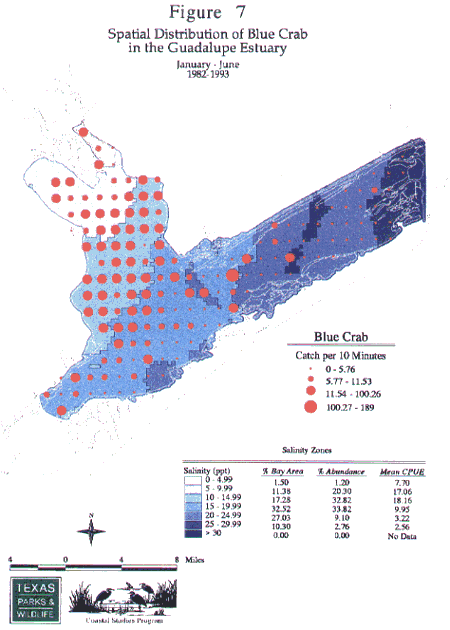
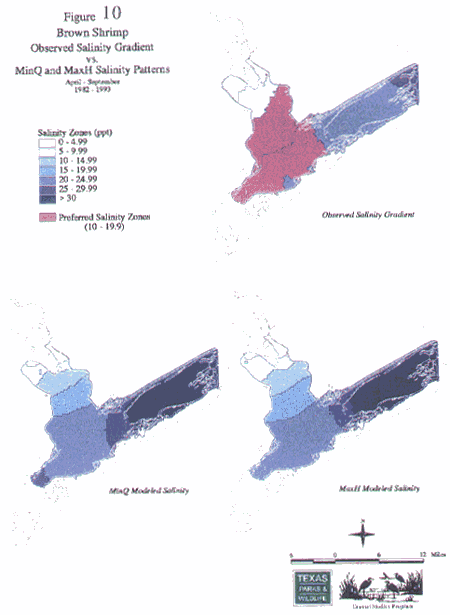
GIS spatial analyses were applied to demonstrate the preferred salinity zones of seven target species in the Estuary: white and brown shrimp, blue crab, Gulf menhaden, Atlantic croaker, bay anchovy, and pinfish. Using the extensive TPWD Coastal Fisheries Resource Monitoring database, we analyzed catch data for the bay covering the range of inflow conditions from 1982 to 1993. Average abundance of young animals caught in otter trawls during the appropriate season was used to determine preferred salinity zones. Spatial correlations were derived between average salinity gradients over the 12 years and average relative catch (CPUE) of each species. Using Arc/Info, GIS overlays were performed between trawl sample catches and contoured salinity zones from the Coastal Fisheries database. (See Figure 7 & Figure 8 for blue crab and brown shrimp).
From the Arc/Info GIS analysis, two critical data values for each species were calculated: 1) the percent abundance of animals in discrete salinity zones, and 2) the percent of bay area occupied by salinity zones. Correlations between salinity zone area and relative abundance allowed salinity preference zones (where peak density occurred) to be identified for each species.Nonparametric statistical tests confirmed that shellfish (brown shrimp, white shrimp and blue crab) and finfish (bay anchovy, gulf menhaden, Atlantic croaker and pinfish) varied in their distribution depending on specific salinity gradients. Each species showed a significant preference for a particular salinity regime, defined as the optimum zone where density was highest (Table 3 ). However, five species (including white shrimp, brown shrimp, blue crab, Atlantic croaker, and Gulf menhaden), all had salinity preference zones between at least 5 and 19.9 ppt, i.e. the mesohaline region of the bay. Two species (white shrimp and blue crab) showed salinity preferences lower than 15 ppt, in the low- to mid-brackish range. Anchovy showed a slightly higher salinity preference zone from 20 - 25 ppt, while pinfish showed a still higher preference of 25 - 30 ppt (both saline preferences). As an example, the preference zone for brown shrimp averaged 47.2% of bay area and accounted for 66.4 % of total abundance in the bay.
Comparison of Observed Salinity Zones vs. MinQ or MaxH Predicted Salinity Zones
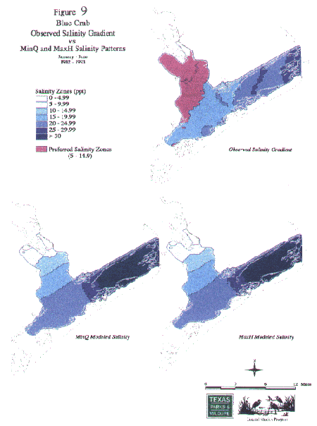
Additional comparisons between the observed salinity preference zone and predicted salinity zones were conducted to determine whether MinQ and MaxH inflows produced sufficient bay area of the preferred salinities. Salinity contour maps of the observed preference zones for each species were compared to salinity maps created by contouring the MinQ and MaxH predicted salinity zones for the same time period. These GIS plots were used to calculate percent of bay area in the salinity zones under the two model cases, MinQ or MaxH, and the observed samples case (see Figure 9 & Figure 10 for blue crab and brown shrimp). The suitability of predicted flows for producing the preferred salinities was evaluated from relative comparisons of areal percentages (Table 3).For white shrimp, blue crab, and brown shrimp (Table 3), MaxH flows produced between 33 and 60 % less bay area within the preferred salinity zone than the observed samples case. The reduction in area was smallest for white shrimp (33 %), and largest for brown shrimp (60 %). MinQ flows produced correspondingly less preferred areas than MaxH (52 % less for white shrimp; 65 % less for brown shrimp). For all seven species, the percentage correspondence between preferred zones for the MaxH and observed samples case ranged from a low of 40 % (brown shrimp) to a high of 101 % (bay anchovy). Because of the many key functions supported by these preferred low salinity, mesohaline habitats (food, shelter, energy maintenance, etc.), inflow levels at least as high as MaxH are considered critical to maintaining such brackish water conditions.
Inflow Recommendation Summary
TPWD staff recommends MaxH (1.15 million ac-ft per yr) inflows as the lowest target value to fulfill the biological needs of the Guadalupe Estuary System on a seasonal basis. TPWD prefers this conservative value of MaxH since it was shown to produce conditions closer to many of the salinity preferences of the target species and wetlands examined in this analysis. This is in contrast to the MinQ case (1.03 million ac-ft per yr). The distribution of flows approximating the historical monthly median pattern provides the most adequate salinity conditions during the critical spring months of May and June. Dryer conditions during summer months (July and August) are naturally expected and can be tolerated if the estuary is prepared by earlier inflows.
The following key biological results are summarized to support the TPWD inflow recommendation:- Correlations between target species' historical average densities and the mesohaline salinity zones of the bay. Densities of five species (white and brown shrimp, blue crab, Atlantic croaker, and menhaden) all showed significant positive correlations with the salinity areas of the bay between 5 to 20 ppt. These preferred salinities are produced by inflows at least as great as MaxH during May through October.
- GIS overlays and time series analyses of salinity regime at upper bay sites.These results show that MinQ salinities at critical times of the year are on the borderline compared to MaxH salinity regimes for sensitive wetland plant species in Upper San Antonio Bay and oyster communities in the Middle Bay. Salinity zone conditions in Upper and Middle Bay areas are better maintained under MaxH flows than under MinQ flows during the critical period, June through September.
- Comparison of total fisheries harvest predicted from the optimization model. The optimization model actually predicts significantly higher (15%) fisheries harvest for the bay under MaxH inflows compared to MinQ levels. The species composition of both the MaxH and MinQ harvests are close to the historical 24-year median harvest, but MaxH supports more blue crab, oyster, red drum, and brown shrimp harvest.
- The GIS results of observed vs. modeled salinity gradients clearly establish that salinity gradients preferred by target species would be best provided by FWI regimes at least equal to the Max H case.
Implementation of Target Freshwater Inflows
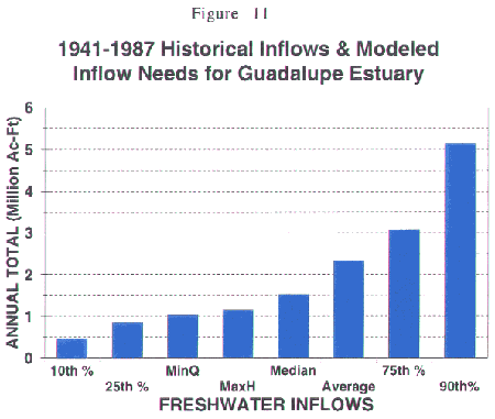
Although the recommended target inflow (Max H) is 1.15 million acre-feet per year, examination of the hydrologic record (Figure 11) shows that during the past 47 year record, the Guadalupe Estuary received greater than 1.52 million acre-feet (the median annual inflow) 50% of the years. Only 23% of the years did the Estuary receive less than the 1.15 million acre-feet target amount for MaxH, and this is substantially lower than the median inflow of 1.52 million acre-feet. When considered in this perspective, the MinQ flow of 1.03 million-acre feet, occurring in less than about 15 % of years, can be judged as being at the lower end of the inflow range. The slightly higher MaxH flows, which only occurred in about 23% of years, would be particularly important in loading the system with nutrient and sediment reserves that are needed during lower-flow years.
During drought conditions, inflows would be much lower than the 1.15 million ac-ft per year (MaxH) amount estimated to meet the biological needs of the Guadalupe Estuary system or the minimum threshold level of 1.03 million ac-ft per year (MinQ). At these lower subsistence inflows, biological productivity and fisheries harvest would be expected to greatly decrease. A major concern of TPWD is that any exacerbated increase in the severity, frequency, or duration of droughts will alter the ecosystem structure by either reducing overall fisheries production or by favoring one fisheries species production at the expense of others, thereby reducing biodiversity. Under reduced riverflow management conditions, however, the frequency of reduced bay inflow levels should not be increased beyond historical occurrences. Watershed management programs should provide target and lower flows at almost the same frequency at which they occurred in the past and retain as much historical variability at higher flows as possible. Although drought cannot be avoided in many cases, the adverse environmental effects due to human-induced increases in the magnitude and duration of naturally occurring droughts should be minimized.
Table 3
Target Species |
Preferred Salinity Zone (ppt) |
Observed Samples Case (% Bay Area) |
MinQ Case(% Bay Area) |
MaxH Case(% Bay Area |
White Shrimp |
5-10 | 6.8 | 3.3 | 4.6 |
Brown Shrimp |
10-20 | 47.2 | 16.4 | 18.8 |
Blue Crab |
5-15 | 28.7 | 13.8 | 14.7 |
Guld Menhaden |
5-10; 15-20 | 32.7 | 13.8 | 17.5 |
Atlantic Croaker |
5-20 | 63.0 | 24.7 | 27.6 |
Bay Anchovy |
20-25 | 32.2 | 35.0 | 32.6 |
Pinfish |
25-30 | 20.8 | 16.0 | 8.0 |