Fishing
- Licenses & Regulations
- ShareLunkers
- Fish Identification
- Fish Consumption
- Texas Freshwater Fisheries Center
Water Resources
- Texas Reservoir Levels
- US Army Corps of Engineers
- Texas Water Issues
- Golden Alga
- Aquatic Vegetation
3802 East End Blvd. South
Marshall, Texas 75672
(903) 938-1007
Tim Bister, Biologist
Local Information
-
Panola County Chamber of Commerce
300 West Panola Street
Carthage, Texas 75633
(903) 693-6634
Nearby State Parks
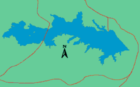
Lake Murvaul
Quick Links: Fishing Regulations | Angling Opportunities | Cover & Structure | Tips & Tactics
Lake Characteristics
Location: On Murvaul Bayou in Panola County,
15 miles west of Carthage
Surface area: 3,397 acres
Maximum depth: 36 feet
Impounded: 1958
Water Conditions
Current Lake Level
Conservation Pool Elevation: 265.5 ft. msl
Fluctuation: 2-3 feet
Normal Clarity: Moderately clear
Reservoir Controlling Authority
Panola County Fresh Water District
154 CR 1839
Carthage, TX 75633
(903) 693-6562
Aquatic Vegetation
Native and non-native aquatic plants are present, with total coverage ranging from 10% to 30% of the lake's surface.
Predominant Fish Species
Lake Records
Stocking History
Latest Survey Report
Lake Maps
Commercial maps may be available.
Fishing Regulations
This reservoir has special regulations on some fishes. See bag and size limits for this lake.
Angling Opportunities
Lake Murvaul has an excellent and highly utilized largemouth bass fishery. The reservoir received national recognition in the 1960s for its trophy bass production and continues to produce bass over 8 lbs. Management strategies have been developed to take advantage of Murvaul's ability to grow large bass. During the late 1990s, a supplemental stocking program was conducted to increase the Florida bass genotype in the population and harvest regulations were modified to protect intermediate-size bass and increase fishing quality. Channel catfish are present in high numbers and provide excellent opportunities for anglers. Quality-size crappie are present with best fishing success in winter and spring. Sunfish (bluegill and redear) are present in good numbers with high numbers of fish over 6 inches available for harvest.
| Species | Poor | Fair | Good | Excellent |
|---|---|---|---|---|
| Largemouth Bass | ||||
| Catfish | ||||
| Crappie | ||||
| Sunfish |
Fishing Cover/Structure
Natural habitat is present is present in the form of inundated timber, aquatic vegetation, and numerous creek channels. An abundance of man-made structures (rip rap, boat houses and docks) provide additional structural habitat.
Man-made PVC cubes have been used to create artificial fish habitat in this reservoir. They were placed by TPWD in cooperation with the the Panola County Fresh Water District. Anglers may use GPS in conjunction with a fish finder to locate these structures.
Use the Habitat Structure Viewer for an interactive map of fish habitat structures and downloadable GPS coordinates.
Tips & Tactics
Although largemouth bass fishing is good throughout the year,
the most productive months are January through March. Jig combinations, oversized
crankbaits and spinner baits are the most popular lures. Fish
are located in deep water along creek channels during winter months and tend
to move into shallow water flats during the spring. Aquatic and terrestrial
vegetation may also be productive habitat to fish during the spring through
fall months. During warmer months, top-water lures can produce
strikes in the early morning hours. Artificial worms are effective in deeper
water off major points and secondary points at mid-day in summer
months
Crappie fishing is steady throughout the year with
higher success rates generally occurring in March and April. Minnows
and artificial
jigs are productive. Jones Branch and the creek channel
near the FM 1971 bridge are popular fishing areas. Best catch rates
for channel catfish occur April through October. Live
baits such as night crawlers, minnows, and catalpa worms are most
effective but commercial prepared dough or stink baits can also be
used. The best months to fish for sunfish are
May and June. Fish can be found near shorelines in 2-6 ft of water.
Earthworms and crickets are good bait choices.