Fishing
- Licenses & Regulations
- ShareLunkers
- Fish Identification
- Fish Consumption
- Texas Freshwater Fisheries Center
Water Resources
- Texas Reservoir Levels
- US Army Corps of Engineers
- Texas Water Issues
- Golden Alga
- Aquatic Vegetation
409
Chester
Wichita Falls, Texas 76301
(940) 766-2383
Wes Dutter, Biologist
Nearby State Parks
Wichita Reservoir
Quick Links: Fishing Regulations | Angling Opportunities | Cover & Structure | Tips & Tactics
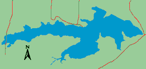
Lake Characteristics
Location: On the south side of the city
of Wichita Falls, off Texas Highway 79
Surface area: 1,224 acres
Maximum depth: 9.5 feet
Impounded: 1901
Water Conditions
Current Water Levels:
City of Wichita Falls (940) 761-7477
Conservation Pool Elevation: 976 ft. msl
Fluctuation: 1 foot
Reservoir Controlling Authority
City of Wichita Falls
1300 7th Street
Wichita Falls, Texas 76307
(940) 761-7477
Aquatic Vegetation
Bulrushes, lotus and cattails
Predominant Fish Species
Lake Records
Stocking History
Latest Survey Report
Lake Maps
None available
Fishing Regulations
All species are currently managed under statewide regulations.
Angling Opportunities
Wichita Reservoir has suffered from golden alga fish kills and severe drought in the past. Since refilling in 2015, the crappie population has exploded. Channel catfish also offer decent angling opportunities.
| Species | Poor | Fair | Good | Excellent |
|---|---|---|---|---|
| Largemouth Bass | ||||
| Catfish | ||||
| Crappie | ||||
| White/Hybrid Bass | ||||
| Sunfish |
Fishing Cover/Structure
This is a shallow lake with bulrushes along the shoreline.
Tips & Tactics
Try the riprap along the dam and the old pier poles near there. The floating pier and boardwalk offer good access to catch fish. Catfishing can be good with traditional baits.